

In the winter, Los Angeles makes for the perfect hiking experience. The mild climate, clear skies, and coziness away from the summer heat make this sunny city ideal for outdoor enthusiasts. Strolling along mountain trails overlooking the city’s glittering skyline while being close to the beauty of nature is an experience you won’t soon forget.
Table of Contents
You may also want to know: How to start hiking
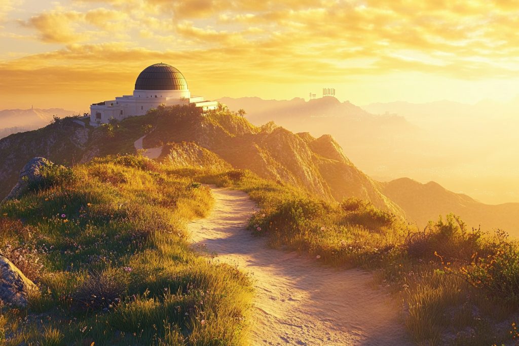
Griffith Observatory Trail
Recommendation: 9.5/10 points
Known as “the best urban hike in Los Angeles,” this trail offers breathtaking views of the city while you enjoy the exercise. On winter mornings, when the fog lifts and the sun gently pours over the mountains, the air is refreshingly clean.
Griffith Observatory Basic Information
- Start: Fern Dell Drive parking lot
- Finish: Griffith Observatory
- Total Mileage: 4 kilometers round trip
- Estimated duration: 1.5-2 hours
- Elevation change: about 150 meters
- Difficulty level: beginner to intermediate
Griffith Observatory Parking Advice
Free parking is available on Fern Dell Drive. It is recommended to arrive before 8am to avoid congestion. Parking is relatively easy on weekdays. On weekends, it is recommended to use Uber or take public transportation to get there.
Griffith Observatory Hiking Tour
Starting at the Fern Dell Nature Museum, the walk gently ascends along a tree-lined trail. Passing several observation platforms, each offering a unique view of the city of L.A. The Charlie Turner Overlook is the best place to photograph the Hollywood sign, especially in the early morning hours of winter, when the sunlight is soft and the views are most dramatic.
From the Charlie Turner Overlook, you can look out over the entire Los Angeles Basin. On early winter mornings, when the coastal fog has yet to lift, skyscrapers loom in the distance and the Hollywood sign stands out in the morning light. It’s also the perfect place to watch the sunset, when the setting sun colors the city in gold and the neon lights come on one by one, the whole city seems to be enchanted.
Griffith Observatory Neighborhood amenities
- Drinking water: There are water fountains in the Observatory building, so it is recommended to bring 1 liter of water for each round trip.
- Rest areas: 6 viewing platforms with benches along the route.
- Restrooms: Clean public restrooms are available at the starting point in Fern Dell and at the Observatory.
- Emergency: Griffith Park Patrol is on duty 24/7, (323) 644-6661
- Nearby hospitals: Kaiser Permanente Los Angeles Medical Center (about 15 minutes by car)
Griffith Observatory Hiking Safety Info
- Cell phone signal: 4G/5G coverage throughout the area
- Wildlife: Occasional coyotes, more active in the morning and at dusk; companionship is recommended.
- Special note: snakes are active in summer, but less so in winter; some sections of the trail are steep, so it is recommended to carry hiking poles.
Hospitals & Emergencies Near Griffith Observatory
Cedars-Sinai Medical Center: 8700 Beverly Blvd, Los Angeles, CA 90048,
Phone: +1 310-423-3277
Hollywood Presbyterian Medical Center: 1300 N Vermont Ave, Los Angeles, CA 90027, Phone: +1 323-660-2450
Griffith Observatory Related Links:
Griffith Observatory Official Website
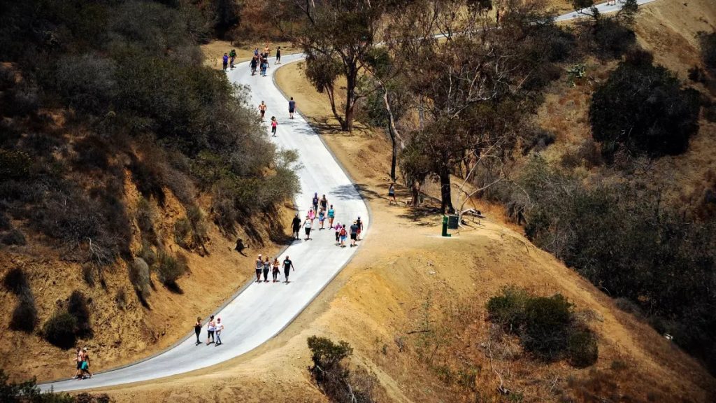
Runyon Canyon Loop
Recommendation: 9/10 points
A favorite hiking trail of Hollywood stars, the clear winter weather makes the beauty of this place even more moving. The winding trail is full of life, with runners in training and locals walking their dogs.
Runyon Canyon Basic Information
- Start: Runyon Canyon Road entrance
- Finish: same as start (loop)
- Total Mileage: 5.6 kilometers
- Estimated duration: 2-3 hours
- Elevation change: about 320 meters
- Difficulty level: Intermediate
Runyon Canyon Hiking Journey
This loop trail offers a choice of three difficulty levels: gently sloping on the east side, steep on the west side, and moderate in the center. With the mild winter sunshine, the steeper routes will not be too tiring.
The highest point of the trail, Clouds Rest (269 meters above sea level), offers 360-degree panoramic views of the Hollywood sign, Griffith Observatory, and on a clear day, even Santa Catalina Island. It is recommended to take a short break here to feel the breeze and enjoy the view of the city.
Runyon Canyon Neighborhood amenities
- Drinking water: There is a water station at the entrance and a refill point in the middle of the trail.
- Resting areas: Benches are provided at several viewing platforms along the trail.
- Restrooms: Public restrooms at the entrance only
- Emergency: Runyon Canyon Park Management Office at (818) 243-1145.
Runyon Canyon Safety Information
- Cell phone reception: Good coverage throughout
- Special Note: Some steep sections are slippery after rain; the trail is not shaded, so it is recommended to bring sunscreen.
Hospitals & Emergencies Near Runyon Canyon
Providence Saint Joseph Medical Center: 501 S Buena Vista St, Burbank, CA 91505, Phone: +1 818-843-5111
Kaiser Permanente Los Angeles Medical Center: 4867 Sunset Blvd, Los Angeles, CA 90027, Phone: +1 323-783-4011
Runyon Canyon Related Links:
Runyon Canyon Park – Official Website (Note: This is the official website of the Los Angeles Parks Department, which provides official information.)
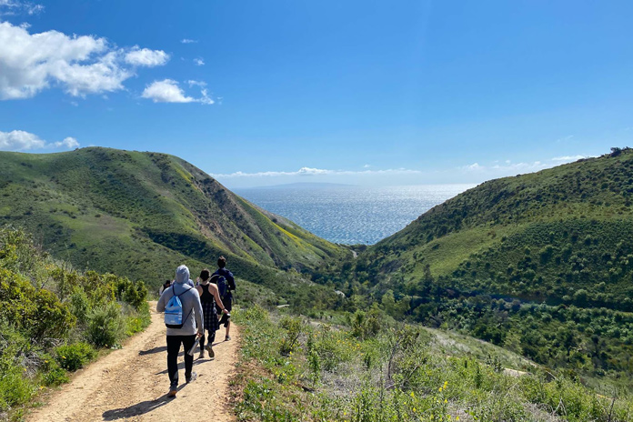
Solstice Canyon Trail
Recommendation: 9.5/10 points
This hike near Malibu is charming in the winter. Traveling along a stream, through a secluded oak forest, exploring historic sites, and ending at an elegant waterfall, it’s a perfect weekend adventure.
Solstice Canyon Hiking Tour
This trail in the Santa Monica Mountains is unique in winter. The creek is full of water, and the Roberts Ranch House ruins along the way are mystical, surrounded by greenery. The waterfall at the end of the trail is about 12 meters high, and the gentle flow of the water is a perfect way to relax while sitting on the rocks and listening to the sound of the flowing water.
Solstice Canyon Neighborhood amenities
- Drinking water: We recommend bringing your own drinking water, there are no rest stops on the trail.
- Rest areas: picnic tables near Roberts Ranch House site
- Rest areas: Picnic tables near Roberts Ranch House site Restrooms: One in the parking lot and one in the rest area.
- Emergency: Santa Monica Mountains Rescue Squad (310) 456-8861
- Nearest Hospital: Providence Saint John’s Health Center (25 minute drive)
Solstice Canyon Safety Information
- Cell Phone Signal: Good signal in most areas, may be weak on valley floor
- Wildlife: Occasional deer and lizards, keep your distance.
- Special precautions: Waterfall area is rocky and slippery, walk carefully
Hospitals & Emergencies Near Solstice Canyon
Providence Little Company of Mary Medical Center Torrance: 4101 Torrance Blvd, Torrance, CA 90503, Phone: +1 310-540-7676
UCLA Medical Center, Santa Monica: 1250 16th St, Santa Monica, CA 90404, Phone: +1 310-319-4000
Solstice Canyon Related Links:
Solstice Canyon Trail – National Park Service (Note: This is the official website of the U.S. National Park Service with official information)
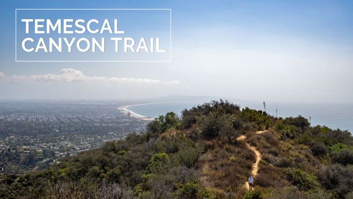
Temescal Canyon Trail
Recommendation: 8.5/10 points
The jewel of the Pacific coast, this route offers the best visibility in winter and a magnificent view of Santa Monica Bay. In the early morning mist, the coastline looms large, creating a moving picture.
Temescal Canyon Hiking Tour
Starting early in the morning, the sea mist has not yet lifted and the air is filled with a salty sea breeze. The first part of the trail passes through a dense canyon, where California laurel and oak trees create a shade of green overhead. After about 1 kilometer, the terrain steepens and the vegetation thins out, replaced by typical Southern California shrubs and wildflowers.
At the highest point of Temescal Ridge, the breathtaking view of the Pacific Ocean is breathtaking. On a clear winter day, the arc of Santa Monica Bay is clearly visible, and ships in the distance seem as small as toys. It’s also a great place to spot wildlife, and dolphins can often be seen playing offshore during the winter months.
Temescal Canyon Neighborhood amenities
- Drinking water: there is a water fountain at the entrance, it is recommended to bring more than 1.5 liters.
- Rest areas: There are several viewing platforms on the ridge, equipped with benches.
- Restrooms: Parking lot and mid-trail facilities.
- Emergency: Pacific Palisades Fire Station (310) 575-8563
Temescal Canyon Safety Information
- Cell phone reception: good on ridges, may be intermittent in canyons
- Terrain Hazards: Some steep sections of trail are muddy after rain, hiking poles recommended
- Risk of getting lost: many switchbacks, download an offline map.
Hospitals & Emergencies Near Temescal Canyon
Saint John’s Health Center: 2121 Santa Monica Blvd, Santa Monica, CA 90404, Phone: +1 310-829-5511
UCLA Medical Center, Santa Monica: 1250 16th St, Santa Monica, CA 90404, Phone: +1 310-319-4000
Temescal Canyon Related Links:
Temescal Canyon Trail – Santa Monica Mountains Trails Council (Note: This is the official website of the Santa Monica Mountains Trails Council with official information)
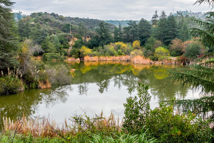
Franklin Canyon Lake Loop
Recommendation: 8/10 points
A quiet spot in the middle of Beverly Hills, this lake loop trail is perfect for the whole family. During the winter months, waterfowl play on the lake and patches of oak trees glow with a soft sheen.
Franklin Canyon Lake Hiking Details
This is an easy hike for the whole family. The trail around the lake is smooth and comfortable, with detailed nature education signs along the way. In the early morning hours, the mist covers the lake and the chirping of waterfowl breaks the silence. On one side of the trail is the calm water of the lake, and on the other side is the old oak forest, where the sunlight through the leaves casts dappled shadows on the ground.
Winter is the best season for birdwatching, and common birds include California Chickadees and North American Cardinals. There are several birding spots around the lake, equipped with binoculars to make this hike fun.
Franklin Canyon Lake Neighborhood Support
- Drinking water supplies: water fountains are available at the visitor center
- Rest areas: several rest areas with umbrellas around the lake
- Restrooms: available at the Visitor Center and near the parking lot
- Emergency: Franklin Canyon Administration (310) 858-7272
- Nearby Hospitals: Cedars-Sinai Medical Center (15 minute drive)
Franklin Canyon Lake Safety Information
- Cell phone reception: good coverage throughout
- Wildlife: Birds and small mammals are common, please do not feed them
- Special note: some of the wooden walkways may be slippery; some areas are off-limits to photographers, please follow signs
Franklin Canyon Lake Local Culture and Customs
This was once the habitat of the Tuna people, and the trail retains some historical sites. There are detailed cultural exhibits in the visitor center, and a visit is recommended to learn about the history of the land. Picnic area use requires advance reservations at the website and is more crowded on weekends.
Hospitals & Emergencies Near Franklin Canyon Lake
Cedars-Sinai Medical Center: 8700 Beverly Blvd, Los Angeles, CA 90048, Phone: +1 310-423-3277
Kaiser Permanente West Los Angeles Medical Center: 6041 Cadillac Ave, Los Angeles, CA 90034, Phone: +1 323-857-2000
Franklin Canyon Park – Official Website (Note: This is the official website of the Los Angeles Parks Department, providing official information)
Los Angeles Winter Hiking Gear Suggestions
Winter temperatures in Los Angeles usually range from 10-20°C. A layering strategy is recommended:
- base layer: quick-drying sports underwear
- middle layer: warm fleece
- Outer layer: windproof soft shell
Necessary equipment:
- Mountaineering shoes or non-slip sneakers
- Hat and sunglasses
- Sunscreen with SPF 30 or above
- 2 liters of drinking water or more
- Energy snacks
- First aid kit
- Cell phone and rechargeable battery
Preparing for a winter hike in Los Angeles before you leave
- Check the weather forecast: the weather in Los Angeles can be very changeable in winter, so keep an eye on the weather within 24 hours before departure.
- Download offline maps: AllTrails or Maps.me are recommended.
- Inform friends and family of your itinerary: share your real-time location.
- check your gear list: especially sunscreen and hydration.
Remember, winter hiking in Los Angeles is a unique experience. Here you can feel the warmth of the Southern California winter sun, appreciate the perfect blend of city and nature, and create your own outdoor adventure story. Whether it’s the silhouette of the city in the early morning mist or the gorgeous evening sun at dusk, every moment is worth savoring.
More Related Links:
